Atlanta BeltLine announces new names for trails. Make sense? Josh Green Mon, 08/12/2024 - 12:36 BeltLine aficionados, prepare to be confused!
According to Atlanta BeltLine Inc., the time has come to toss out everything you thought you knew about boundaries for sections such as the Eastside Trail and Westside Trail and relearn what they actually are—for the sake of clarity, and the good of future BeltLine patrons.
As part of sweeping changes that included a new BeltLine logo, branding, and website unveiled last month, BeltLine officials recently rolled out revised names (or end-points) for completed and forthcoming segments of the trail, laying a roadmap for how future sections will be identified. (Sorry, Reynoldstown: That popular trail in your backyard isn’t technically the beachfront Eastside Trail any longer. Ditto for the Westside Trail in Adair Park.)
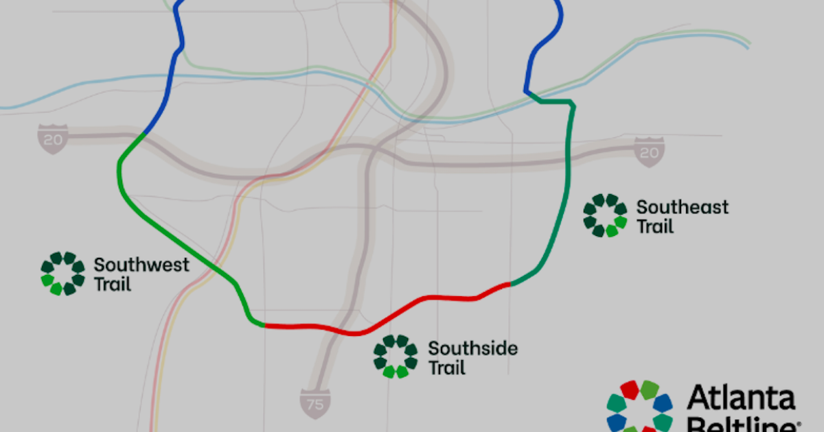
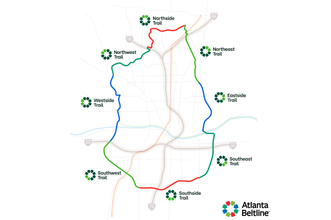
BeltLine leaders say the revised corridor names around the 22-mile loop’s clockface align with logical, cardinal directions and will make it easier for future visitors to navigate the full trail. The new naming tactic also divvies up trails around the corridor into lengths that are closer to being equal.
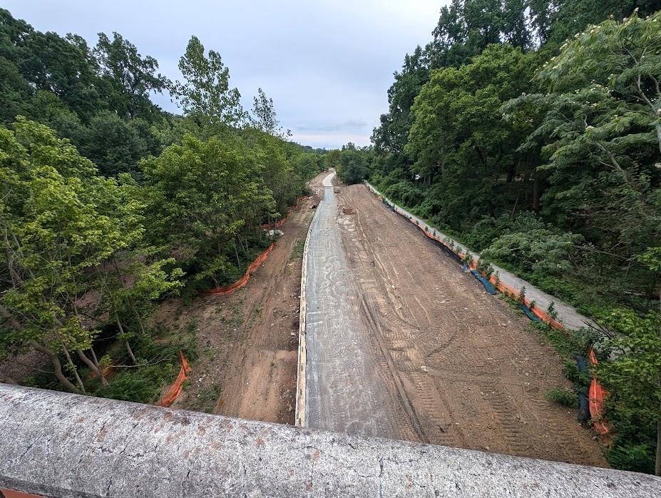 Looking north toward Buckhead, a view of Northeast Trail construction in July from Piedmont Park’s historic Park Drive Bridge. Josh Green/Urbanize Atlanta
Well-known landmarks and barriers—such as Krog Street Tunnel, Interstates 75 and 20, and major roadways—were used to create “breaks between the different areas of the corridor that are easy to understand, especially for those unfamiliar with the trail,” per a BeltLine announcement.
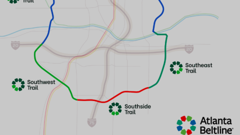
Previously, just five names were used for BeltLine sections: Southside, Westside, Northwest, Northeast, and Eastside trails.
All segments of the trail will keep their current names—such as sections of today’s Southside Trail—until construction is finished and the trail is open, per BeltLine leaders.
Below is a breakdown of how Atlanta BeltLine Inc. will define the eight mainline trail sections moving forward. We’ve added a few notes with important, recent construction updates:
Northside Trail: Once complete, this portion will run for 2.9 miles, beginning near I-75, and running to Peachtree Creek. It includes the open section that runs through Tanyard Creek Park.
Northeast Trail: The Northeast Trail will extend for 2.6 miles from Peachtree Creek just north of I-85 to Monroe Drive at Piedmont Park. One portion of the trail is currently open—passing by Ansley Golf Club and Ansley Mall—while the other two are either under construction or nearing the start of construction. (According to the BeltLine’s latest construction updates, designs for the Northeast Trail’s Segment 3—the connecting thread to MARTA’s Lindbergh station, PATH400, and the Armour-Ottley business district—have reached 90 percent complete; the BeltLine expects to open construction bids next summer.)
 Atlanta BeltLine Inc.
Eastside Trail: The Eastside Trail is fully complete and extends for 2.4 miles, beginning at Monroe Drive near Piedmont Park and runs to Krog Street Tunnel at DeKalb Avenue.
Southeast Trail: Once complete, the Southeast Trail will run for 2.5 miles. It will connect to the Eastside Trail at Krog Street Tunnel, and continuing through Reynoldstown and Glenwood Park to Boulevard Southeast. The northernmost portion of this segment is open. (Beltline officials recently noted “underground utility challenges” that construction crews encountered at United Avenue have pushed back the scheduled completion date for Segments 4 and 5, from summer 2025 to sometime next fall.)
Southside Trail: Starting at Boulevard, the Southside Trail will extend for 2.4 miles to Metropolitan Parkway. The area between Pittsburgh Yards and Metropolitan is currently open to the public. (Substantial tree-clearing and other heavy work started earlier this month for Segments 2 and 3 just west of Boulevard; the BeltLine expects the full trail to open by early 2026, followed by landscaping work.)
Southwest Trail: This 2.6-mile section is also fully built out and runs from Metropolitan Parkway to I-20, connecting neighborhoods such as Pittsburgh, Adair Park, and West End.
Westside Trail: The longest section, the Westside Trail, will extend for 3.2 miles once finished. Its boundaries will be I-20 on the south end, up to West Marietta Street. The section from Washington Park to Law Street is closed for construction. (That work is scheduled to finish next summer, with a link to the Westside BeltLine Connector that stretches into downtown.)
Northwest Trail*: The only BeltLine section that’s either fully under construction or in design, the Northwest Trail will extend 2.4 miles, from West Marietta Street up to I-75.*
…
Follow us on social media:
Twitter / Facebook/and now: Instagram
• BeltLine news, discussion (Urbanize Atlanta)
Tags
Atlanta BeltLine Beltline Atlanta BeltLine Atlanta Trails Parks and Rec Parks and Recreation Eastside Trail Southeast Trail Southside Trail Southwest Trail Westside Trail Northwest Trail Northside Trail Northeast Trail BeltLine Construction
Images
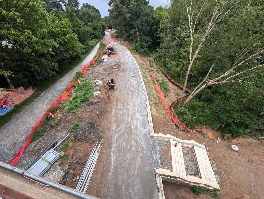 How construction grading and wall work is coming together in the Northeast Trail corridor. Josh Green/Urbanize Atlanta
Atlanta BeltLine Inc.
Looking north toward Buckhead, a view of Northeast Trail construction in July from Piedmont Park’s historic Park Drive Bridge. Josh Green/Urbanize Atlanta
Subtitle Changes aim to make navigating future 22-mile loop easier, dividing trails into equal-ish portions
Neighborhood BeltLine
Background Image
Image
Before/After Images
Sponsored Post Off